Lake Hartwell, one of the largest and most popular lakes in the southeastern United States, was created by the U.S. Army Corps of Engineers (USACE) between 1955 and 1963. Originally designed as part of a flood control and hydropower project, it has since become a major public recreation area, attracting millions of visitors each year. Situated on the border between Northeast Georgia and Upstate South Carolina, Lake Hartwell spans nearly 56,000 acres at normal pool stage and boasts an impressive 962 miles of shoreline.

Your go-to resource for everything about Lake Hartwell. From boating and fishing tips to local events, dining, and real estate, we provide comprehensive insights into life on and around the lake.
acres of water
public boat ramps
acres of surrounding land
Lake Hartwell was constructed as a multi-purpose reservoir designed to control flooding along the Savannah River, provide hydroelectric power, and facilitate recreational activities. Completed in 1962, the project involved a significant investment of nearly $90 million and took about eight years to finish. The lake was officially opened to the public for recreation in 1968 and has since become one of the most visited lakes in the United States, drawing more than 9 million visitors annually.
In addition to the links below, you can see a USACE map of the lake and surrounding campgrounds, docks and parks, as well as current safety regulations and lake levels.

With this map you are able to zoom in and out using the controls on the left. You can also switch between Map and Satellite view with the buttons in the upper right hand corner to switch between navigational and more realistic landscape imagery. By clicking inside it, you can drag the map around to your desired location.

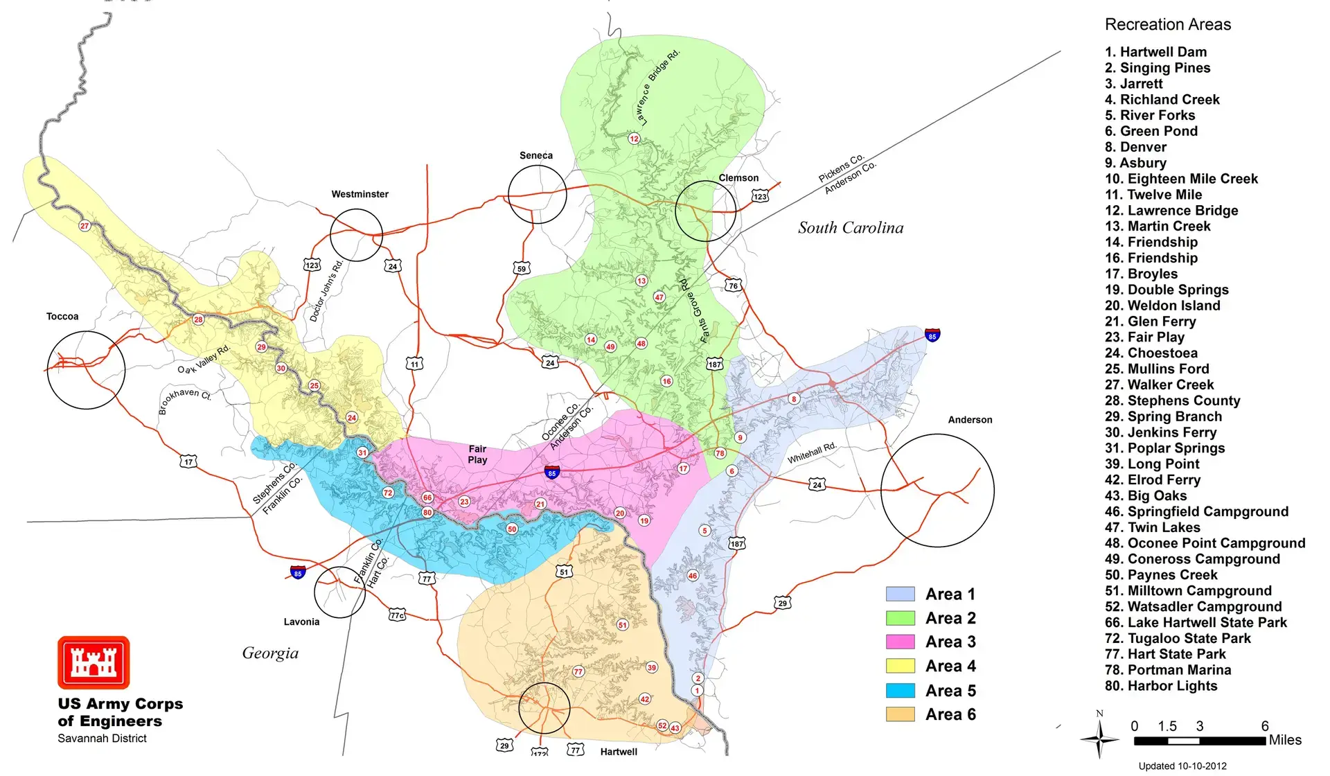
With this map, you can see the 6 primary shoreline areas as designated by the US Army Corps of Engineers (USACE). These include the shorelines near the larger communities around the lake such as Anderson (Area 1), Clemson/Seneca (Area 2), Fair Play (Area 3), Toccoa/Westminster (Area 4), Lavonia (Area 5) and Hartwell (Area 6). This map also shows a number of the larger recreational areas around the lake.

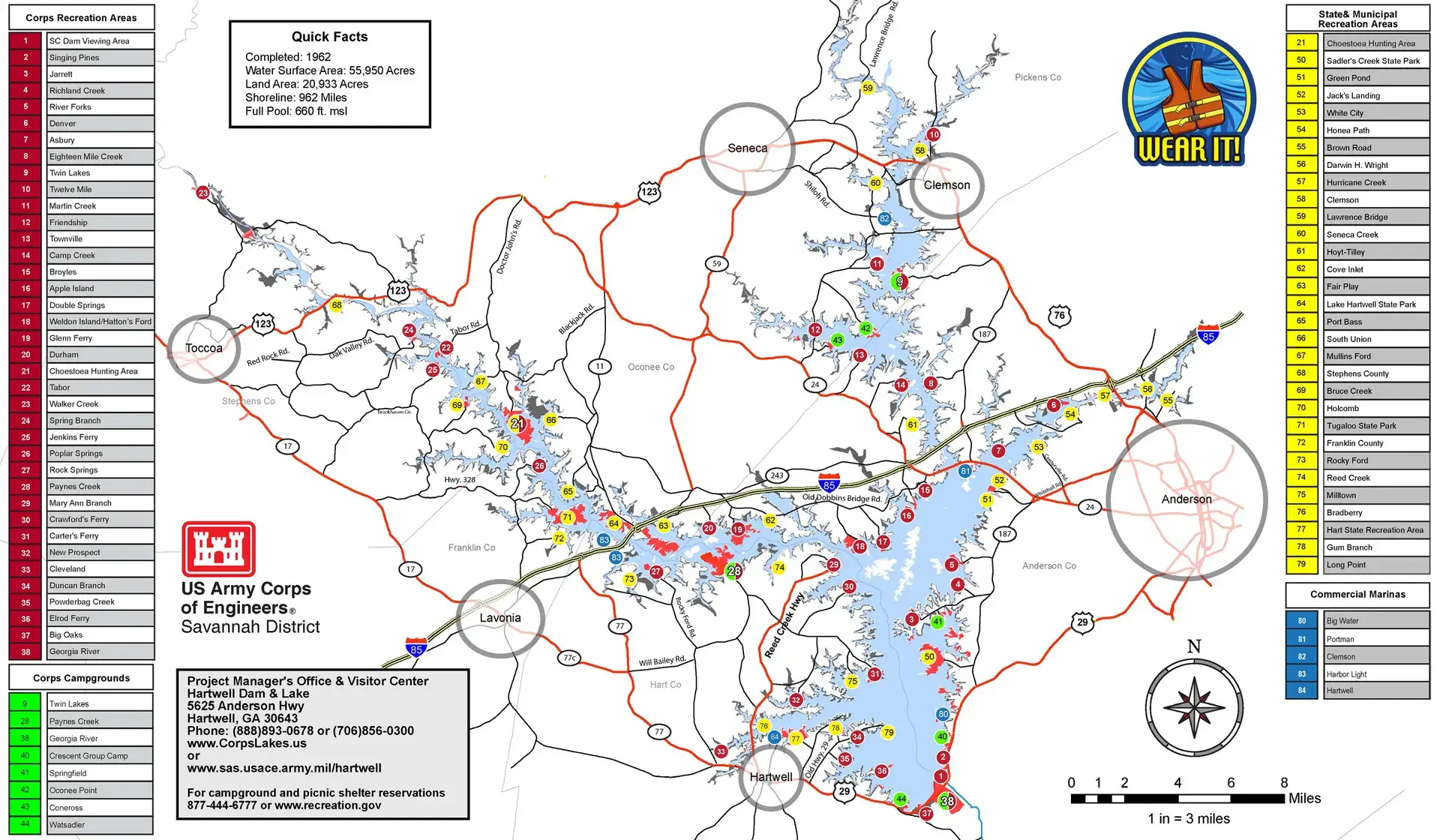
With this map, you can see a complete listing of the 5 Commercial Marinas (blue), 31 State & Municipal Recreation Areas (yellow), 38 USACE Recreation Areas (red) and 8 USACE Campgrounds (green). As you can see, besides being out on the water, there is an incredible number of recreational options around the lake as well.
Yes, dock installation requires a permit from the USACE. Permits are only issued for shorelines designated as green zones.
The shoreline is divided into four zones, as defined in the Shoreline Management Plan:
Visit the USACE office with the property details to confirm dock permit eligibility. This information is vital as it can significantly impact property use and value.
Permission is required to cut any trees on USACE property. A Ranger will inspect and mark trees that can be removed, typically for safety reasons. Contact the USACE for more details.
Public boat ramps are available at state parks, USACE parks, marinas, and designated launch sites. Some are free, while others charge a small fee. These locations are marked on Lake Hartwell maps.
Visit the US Army Corps of Engineers (USACE) website for detailed information about Lake Hartwell’s history. The site includes photos, early regional history, and resources about the Savannah River Basin’s water resource development.
The Shoreline Management Plan outlines rules for using Lake Hartwell’s public lands, including private activities like boat docks, underbrushing, and utilities. It offers guidelines for managing the shoreline while balancing public and private use. The plan was created by the USACE with public input. You can find the plan here.
Yes. The Shoreline Management Plan includes information on shoreline protection. Contact the USACE for guidelines and permits regarding landscaping and erosion prevention methods.
Maps are available at local sporting goods stores, marinas, and boating supply shops.
Interactive phone apps showing location on lake, channel markers, and lake depth are available (most at a cost) for mobile phones. Most major marinas and fishing stores will have details.
The lake’s levels vary by season according to the “rule curve”:
Daily historical lake levels since 1962 are available on the USACE website under the “Annual Summary” section.
The drought plan manages water releases from Lake Hartwell and the Savannah River Basin during severe droughts. It includes staged reductions in water release as drought conditions worsen. The full plan be found here.
Join the Lake Hartwell Association today and become a vital part of the effort to protect and preserve the beauty and vitality of Lake Hartwell for generations to come. Your membership helps fund projects that improve lake conditions, promote responsible recreation, and ensure that Lake Hartwell remains a treasured resource.